By Liz Slocum Jensen June 25, 2018
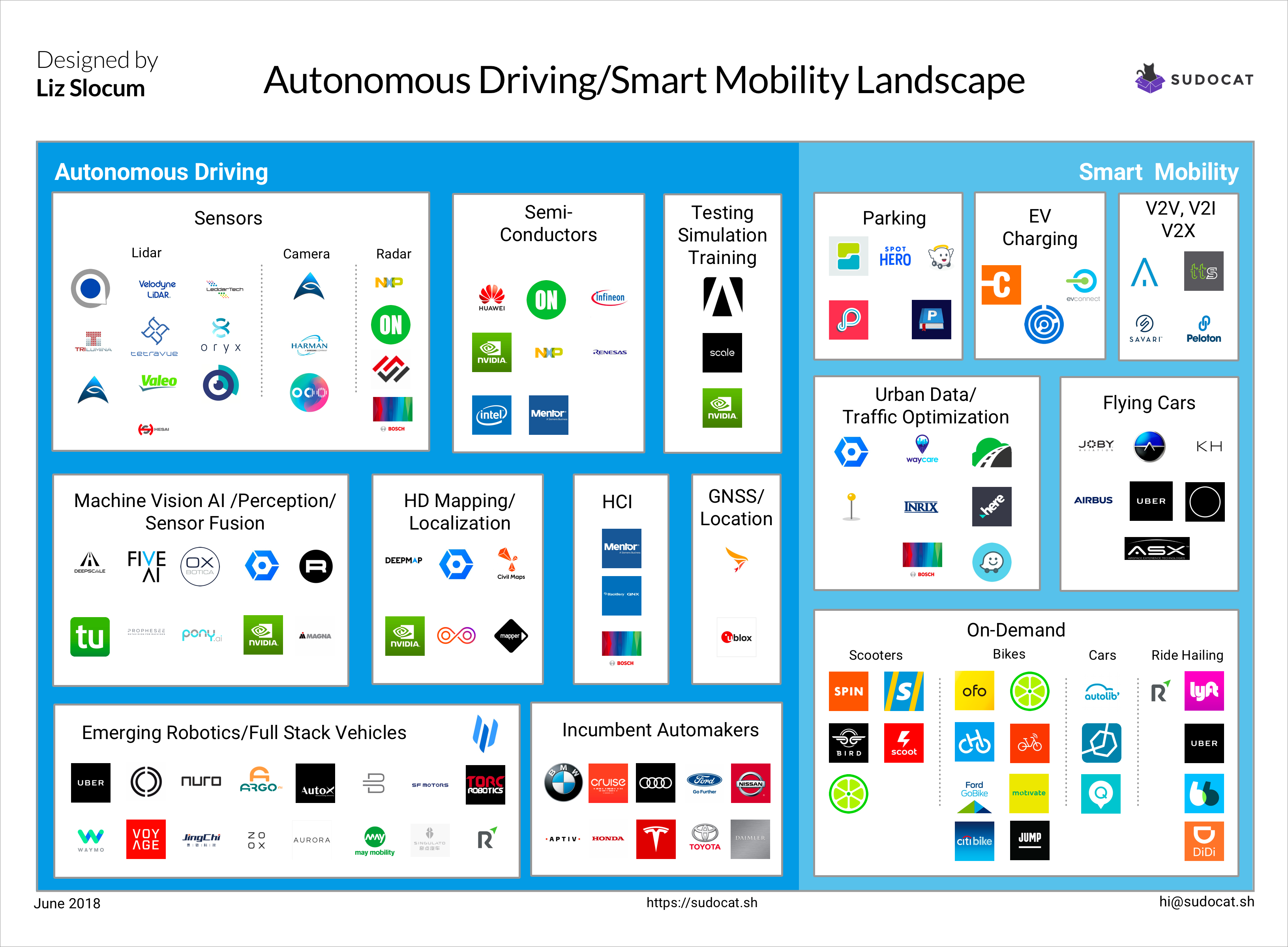
The transportation technology sector has expanded significantly since I last did a market landscape on connected car tech in 2016. Here’s a landscape that takes a deeper dive into autonomous vehicles (AV). I also included Smart Mobility because as we envision the self-driving world, it’s worthwhile to have the context of data and smart mobility services.
Sensors: Lidar - Camera - Radar These are the three sensors on the car to collect information on the world around them. LiDAR for automotive has become really competitive in the last few year as technology has become less cost-prohibitive. The main issues with previous LiDAR systems was that they were very expensive (from $8000 to $80,000) and that they had constantly moving parts. In the last few years, companies such as Velodyne and Valeo are producing solid-state LiDAR for less than $500. This makes it easier and cheaper for robots of all kinds.
Semi-conductors NXP and ON Semiconductors have been critical in processing the high rate of mass data required for autonomous driving. NVIDIA is known for processors but as you can see in this infographic, it’s working in a lot of spaces within AV.
Testing/ Simulation Training Scale API provides training set data for AVs. Ansys provides simulation software. I see opportunity for significant growth in this space since third-party testing environments help ensure an outside set of eyes to help test safety.
Machine Vision AI/ Perception/ Sensor Fusion In order to achieve accurate, high-resolution images of it’s environment, companies like Oxbotica and DeepScale fuse data from various sensors in order to provide a real-time image of the AV’s environment.
HD Mapping/Localization Autonomous driving requires accurate location within centimeters. This is the next generation of mapping that answers the questions: Where am I? What does my environment look like? What are the shapes and objects near me?
Civil Maps takes a variety of sensor data to map static objects like road signs and building and dynamic. Mapper is taking a crowd-sourcing model to get the information by also including data collected from its community’s phones.
HCI - Human Computer Interaction QNX, Bosch, and Mentor Graphics are ensuring that our experiece interacting with the vehicle is pleasant and intuitive.
GNSS/Location Swift Navigation and u-blox are embedded systems that enable navigation with satellite location information from networks like GPS, GLONASS, Galileo, Beidou.
Emerging Robotics/Full Stack Vehicles Instead of partnering with and supplying existing automakers, new automotive startups like JingChi, May Mobility, and Optimus Ride are building their own full stack vehicle.
Incumbent Automakers These are the legacy automakers that are household names. In some cases, these companies made significant gains into the AV space via acquisition. In 2016, [Cruise Automation](http://Cruise Automation) was acquired by GM. In 2017, Delphi Automotive acquired NuTonomy and then rebranded to Aptiv.
Parking Some people are envisioning a world in which transportation is service of AV’s and personal car ownership will dwindle. In the meantime, existing personal cars will be on the road for a long time. This means that having data and services for parking, like SpotAngels will be relevant in the foreseeable future.
EV Charging The electric vehicle (EVs) sector has really expanded from the Chinese market. Having data and services for charging will be a common sight in connected cities.
V2V,V2I,V2X Vehicle-to-Vehicle (V2V), Vehicle-to-Infrastructure (V2I), and Vehicle-to-Everything (V2X) communications is the underpinning of smart, connected mobility and the Internet of Things (IoT). This categories covers a variety of solutions from Peloton creating trucking platoons to Traffic Tech Services enabling Audi’s to know when a signal light will turn green. The V2X sector includes having the car as a mobile sensor. For example, INRIX is using data from the car (such as temperature and windshield wiper data) to report weather conditions in microclimates.
Urban Data/Traffic Optimization Understanding how populations move are helpful for traffic optimization, urban planners, real estate developers, and consumers of navigation apps. INRIX and HERE have embedding sensors in the road infrastructure. Streetline Data is a data analytics that sources from census data, parcel data, and road network data with both navigation-GPS and Location-Based Services data sets to understand and predict urban traffic.
On-Demand: Scooters, Bikes, Cars, Ride-Hailing On-demand mobility has really transformed in the last 5 years from cars.Some investors think these personal mobility services the next hyper-growth unicorn. Even Uber expanded their on-demand mobility offering with their acquisition of Jump. On-demand scooters from Bird and Spin have infiltrated cities like Austin and San Francisco. Bikes have swept through China; sometimes with shockingly unexpected outcomes of oversupply and disposal (check out this pictorial from The Atlantic).
Flying Cars The technology is a lot further along than you think. ASX projects that their flying vehicle will be ready for demonstration by 2020 and in the 50 busiest cities in America by 2026.